Meteorological, oceanographic and environmental forecasts
Maritime routing calculations are not only based on a vessel's fuel consumption and performance curves, but also on meteorological forecasts and environmental data. The quality of the routing is directly linked to the quality of this data.
Dedicated interfaces
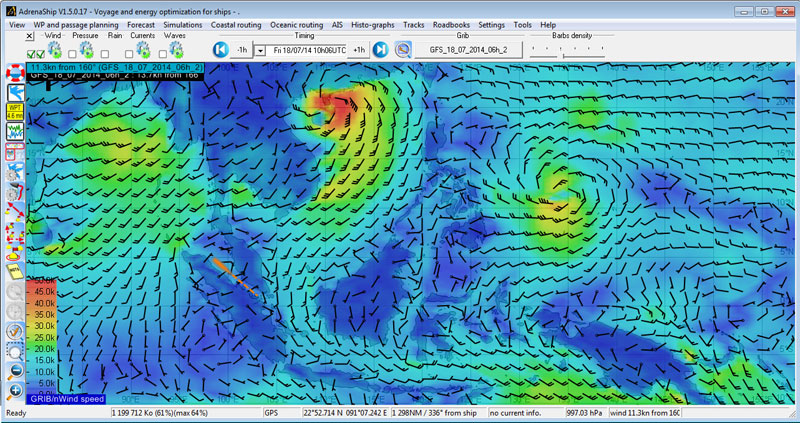 The AdrenaShip routing software features dedicated interfaces for receiving meteorological and environmental forecasts, together with tools for viewing and comparing this data.
NOAA data
The NOAA, National Oceanic and Atmospheric Administration, is the American agency responsible for surveying the ocean and the atmosphere. To this end, the agency provides meteorological forecast data in the form of GRIB files.
This is referred to as the American model, or GFS (Global Forecast System).
Different types of data are available, including:
- Direction and strength of wind
- Atmospheric pressure
- Rainfall
- Air temperature
- Wave data
- Atlantic currents (including the Gulf Stream)
This meteorological data is also available as historic GRIB files, containing data collected since 1979. This data, which is integrated into the AdrenaShip software, allows routing statistics and fuel consumption for a single leg or a whole passage to be calculated.
All of this data can be downloaded for free using the AdrenaShip software, where it can be viewed and used in routing calculations.
SHOM data
The SHOM, the French Marine's hydrographic and oceanographic service, aims to guarantee the quality and availability of information pertaining to the physical maritime, coastal and ocean environment. To this end, it provides forecasts of environmental data relating to tides and currents, which is integrated into the AdrenaShip software:
- SHOMAR is an application that calculates tides throughout the world.
- Tidal current atlases for the French coast, the Atlantic, the English Channel and the North Sea.
 In the same way as NOAA data, SHOM data is presented in the AdrenaShip software and used in routing calculations. Data for currents are essential for calculating coastal routing and ETA. the AdrenaShip licence include SHOM data.
Proudman currents
Proudman current data is provided by the National Oceanography Centre, based in the United Kingdom. This private oceanographic research laboratory issues data about currents that is the result of a highly sophisticated mathematical model.
The Proudman model applies to the British Isles, the North Sea and the English Channel, and complements data provided by the SHOM.
Proudman data is included in the AdrenaShip licence.
These data sources are those recommended and supplied by ADRENA. However, it is also possible to integrate GRIB files from other providers, such as Météo France or Tidetech.
Environmental influence on a vessel's passage
Every type of forecast can have a varying impact on route planning.
Autonomy
The quality of the forecast has a direct impact on the quality of route planning. The AdrenaShip tool is an important asset on board so that the vessel's course can be updated in line with each new forecast or with any event that may have a negative impact on the route.
Safety
Considering the sea state and wind when choosing a route is essential in order to ensure the safety of the vessel, crew and cargo when at sea.
For example, a gas tanker could be subject to the dangers of sloshing on its route. AdrenaShip serves as an aid to decision-making for route planning by taking into consideration the forecasted sea state.
Efficiency
The AdrenaShip routing software bases its calculations on forecasts for wind, current and sea state, and correlates these with efficiency and fuel consumption curves. The software is then able to suggest routes based on a passage time/fuel consumption ratio.
Reliability
Coastal routing is a unique solution proposed by AdrenaShip, which allows the simple calculation of a vessel's ETA (estimated time of arrival). This ETA is very sensitive to the effects of the current.
For example, a container ship can very easily find out if it can still arrive at its slot in Dunkirk dock on time despite leaving Montoir de Bretagne three hours behind schedule, or whether it is better to postpone the slot and reduce speed (saving fuel and port fees).
The better the quality of this meteorological data and the "hotter off the press" it is, the better the choice of optimum route and speeds. Taking meteorological forecasts into consideration is not only important for controlling operating costs and saving fuel, but also for ensuring the safe transit of vessels at sea.
Please refer to the "Coastal routing" and "Ocean routing" pages for more detailed information about choosing a route with the objectives of controlling costs and time.